On Monday morning, North Alabama and southern Middle Tennessee are locked in a dangerous stretch of Arctic cold that will linger through most of Tuesday, with hazardous road conditions and life-threatening wind chills expected across the region.
According to the National Weather Service office in Huntsville, the impactful winter storm that moved through the Tennessee Valley over the weekend has ended, but its most dangerous effects are just beginning as a surge of Arctic air settles in behind it.
A Cold Weather Advisory is in effect area-wide through noon Monday and again from midnight Monday night through 10 a.m. Tuesday, with wind chills expected to fall into the single digits and as low as 5 below zero at times. Overnight lows across North Alabama and southern Middle Tennessee are expected to range from 10 to 15 degrees, with temperatures remaining below freezing until at least Tuesday afternoon.
“This is dangerous, life-threatening cold,” said Todd Barron, a meteorologist with the National Weather Service in Huntsville, during a Sunday afternoon briefing. “Temperatures could fall into the single digits in some areas, and when you factor in the wind, wind chills will drop into negative numbers. This is not something to take lightly.”
Black ice a major concern
While precipitation has ended across most of the region, lingering moisture combined with rapidly falling temperatures is expected to create widespread black ice, especially on bridges, overpasses and less-traveled roads. The NWS warns hazardous driving conditions could persist through Tuesday and in some sheltered areas, even into Wednesday.
Drivers are urged to use extreme caution or avoid travel altogether if possible, particularly during the overnight and early morning hours.
Ice storm impacts continue in northwest Alabama
An Ice Storm Warning remains in effect for Lauderdale, Colbert and Franklin counties through Monday evening, though officials say it could be lifted earlier as precipitation has moved out. Gusty winds of 10 to 15 mph, with gusts up to 25 mph, could still bring down ice-weakened trees and power lines in northwest Alabama.
“With lingering ice on trees and increasing winds, there’s still potential for downed limbs and power outages,” Barron said.
Those without reliable heat are especially vulnerable as the cold intensifies.
Flooding and lingering impacts
Minor flooding issues continue in some areas due to heavy rainfall over the weekend. Indian Creek has reached flood stage, and additional river rises are being monitored across the region.
Despite the cold, some sunshine is expected to break through Monday afternoon and continue into Tuesday and Wednesday. However, forecasters stress that sunshine will do little to improve road conditions until temperatures climb above freezing.
Another cold snap ahead
Even as the region looks toward midweek improvement, forecasters are already watching another Arctic air mass expected to move into the Tennessee Valley late next week. The Climate Prediction Center’s 8- to 14-day outlook shows a 60–80% chance of much below-normal temperatures around February 1, with morning lows potentially falling into the low 20s or colder.
“We’re not out of the woods yet,” Barron said. “Another round of hazardous cold is possible late next week.”
Safety reminders
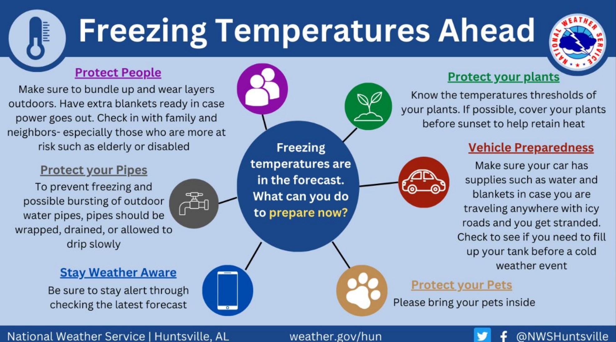
The National Weather Service urges residents to take steps to protect people, pets, plants and pipes during the prolonged cold spell. Pipes are particularly vulnerable to freezing when temperatures fall into the teens or lower.
Anyone spending time outdoors should dress in layers and limit exposure to avoid frostbite and hypothermia.
“This is the kind of cold that can become life-threatening quickly,” Barron said. “Take it seriously, and take precautions now.”