HUNTSVILLE — It’s the eve of a holiday weekend and it looks like the weather may dampen some of the outdoor events as we unofficially welcome summer.
According to the National Weather Service Huntsville office, clusters of showers and
thunderstorms are forecast to develop across the region during the afternoon and evening
today.
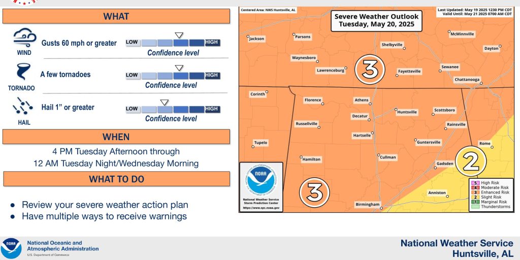
“A slow-moving front to our northwest will continue generate clusters of showers and thunderstorms,” the forecasters said. “A low threat of strong to marginally severe storms will develop across the Tennessee Valley this afternoon and evening.”
Unfortunately for those planning outdoor activities, the forecast is a “lather, rinse, repeat” version of weather.
“Medium to high chances (60-80%) for showers and thunderstorms are forecast Friday and Saturday,” the office said. “Some of these storms may become strong to severe, especially from the late morning through the evening hours.
“A greater threat for severe weather may evolve Sunday evening into Sunday Night ahead of a strong cold front, with all modes of severe weather possible.”
The forecast office said it is watching how quickly the front to the northwest pushes into the Tennessee Valley on Friday.
“If this front moves further south than currently depicted and stalls over the Tennessee Valley, our severe weather threat may become slightly higher,” forecasters said. “Additionally, locally heavy rainfall and a low threat for flooding may develop as well.
“The track and timing of the low pressure system on Sunday which will impact the magnitude of the severe weather threat in the Tennessee Valley as well as the timing window for the main severe threat.”