HUNTSVILLE – Lingering conditions from the front that moved into the state could continue to make driving a treacherous endeavor into next week, according to the Huntsville office of the National Weather Service.
Frigid and near-record lows will continue to be a menacing presence, with another front sweeping in from the west late Thursday to drop temperatures again heading into the weekend.
It’s not clear whether or not snow or icy conditions will accompany the front, but roads could still remain dangerous in places.
Prior to the arrival of the next system, which NWS Meteorologist Kurt Weber said could be a faster moving “clipper’’ front, wind chill advisories and warnings remain in the region.
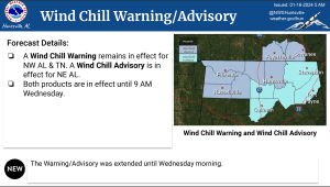
NWS issues a wind chill advisory when seasonably cold wind chill values but not extremely cold values are expected or occurring.
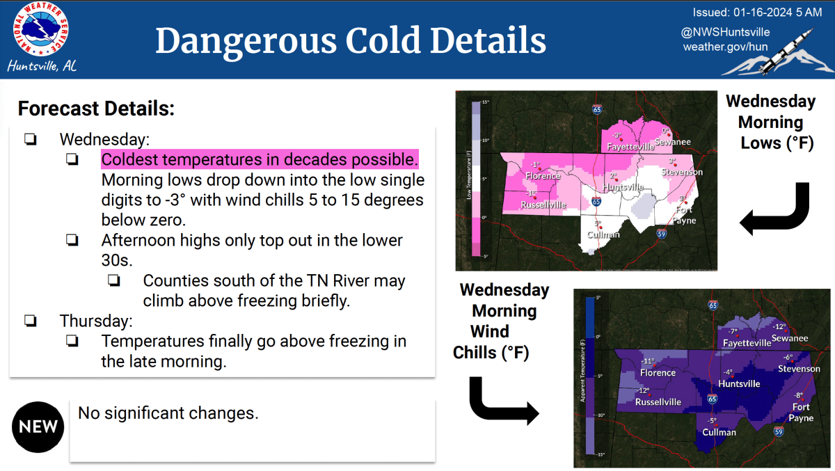
A wind chill warning remains in effect for northwest Alabama and Tennessee. A wind chill advisory is in effect in northeast Alabama. Both remain in effect until 9 a.m. Wednesday. Rain is expected to return Thursday, but snow or sleet remains uncertain.
Warming temperatures will likely lead to a mostly rain event when the next system arrives Thursday. A brief changeover to a wintry mix is possible Thursday night into Friday morning as temps fall near or below freezing.
Chances for accumulating snowfall are less than 50 percent across the entire forecast area. Dry weather is expected to return and help clear the hazardous road conditions early next week.
“We’ll just have to see what happens that might end up being a little more of a freezing rain type event if we get the change over from rain,” Weber told 256 Today. “It’s pretty uncertain right now, but I’m not looking at the kind of what we had with this one. Late Thursday and Thursday night will probably be much less precipitation, including the rain.
“That being said, if it ends up being half of the freezing rain, that’s still very hazardous conditions. It doesn’t take much if it’s a freezing rain type of event to cause widespread problems. It’s something we’ll have to watch as we get closer to that late Thursday afternoon, particularly Thursday night.”
Weber added, “We might have some kind of wintry episode again, maybe not as heavy, but it may be impactful despite that. Basically, we probably won’t see a significant improvement in this (road travel) stuff until early next week as far as having to watch your driving and hazardous conditions of at least some icing lingering, maybe a decent amount.’’
Chances aren’t likely for temperatures to reach the recent low of minus-4 degrees Huntsville experienced in 2017, but if they stay under 20 today, the storm will produce the coldest extended period since 1989.
“I think that will tie if not break a record for Huntsville and maybe the Shoals,” Weber said.
As for the snow recorded this week, while Huntsville had more sleet than the white stuff, anywhere from 2-5 inches fell around Meridianville, in Lauderdale County and along the Alabama-Tennessee line. Weber theorized an appearance of warm air in Huntsville may have led to less snow.
“We weren’t far off from getting a lot of snow everywhere,” he said.