HUNTSVILLE – With frigid temperatures finally releasing its stranglehold, residents in the Tennessee Valley were able to stretch their legs outside without freezing and roads lost their dangerous invitation on local routes.
But everyone might be wise to restock or replenish needed items now, though, before a reinforcing arctic air mass enters the region promising to re-ice travel routes before bedtime for most.
For the coming couple of days, the advice is a refrain recently heard around the region – stay inside where it’s safer.
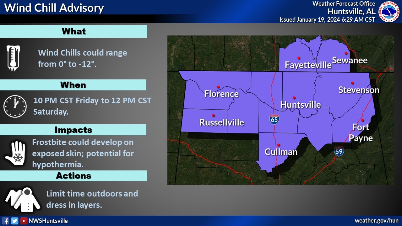
“We’re looking at another bitterly cold surge of Arctic air to spread into the area starting tonight and that’s gonna continue probably well into the day Sunday,” NWS meteorologist Dana Griffin said. “We’re looking at lows tonight and Saturday night dropping into the single digits and probably wind chills dropping below zero. Those temperatures are gonna be very dangerous.
“So, the best advice for people is to stay in, certainly protect any exposed pipes, watch out for any pets. Check on the more vulnerable parts of the populations – your elderly people, maybe people in low-income homes and such that may not have the best ventilation or heating.”
According to the National Weather Service Huntsville, the most likely location for temperatures to rise above freezing for several hours this afternoon is across Cullman, Marshall and Dekalb counties.
A parent asked us to share this because their 25yo old son didn’t believe them about the roads. @spann pic.twitter.com/yEnClkDhSn
— Morgan County Sheriff’s Office (Alabama) (@morgan_sheriff) January 19, 2024
Treacherous driving conditions will return. Water on local roads will refreeze into “black ice” as temperatures again fall below freezing. Although the combination of wind and very dry air will help to evaporate some surface moisture, patches of black ice are expected to persist through Sunday morning.
The forecast for Saturday and Sunday calls for the return of problematic driving conditions and more uncomfortable weather for those going outside. Travel issues may persist, especially on secondary roads through Sunday morning.
Highs on Saturday will only rise into the low to mid-20s, but sunshine and breezy northerly winds may help to dry the roads. The NWS has higher confidence temperatures will rise above freezing on Sunday afternoon, leading to improvement in travel issues.
For those who need or choose to travel, take precautions.
“They need to be sure that they bundle up, dress in layers, have an emergency kit or have something just in case you have car trouble or something happens,” Griffin said. “Because if you’re out, especially if you’re stranded in the evening or at night, those temperatures can be really dangerous if you don’t have immediate shelter or immediate help.”